Page
Estimate, Measure and Calculate
Completion requirements
View
The farmer sometimes needs to estimate, measure and calculate agricultural data.
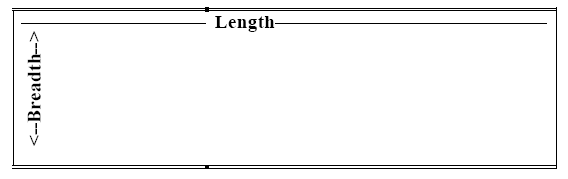
Length and Breadth
Length is always the longer side(s) of a shape, while breadth is the shorter side of a shape. In the example below, length is indicated by the double line while breadth is indicated by the single line. Length and breadth is measured in meters. Any shape that has length and breadth is a two-dimensional shape.
You can estimate the length and breadth with your fingers. The length of one side is about six fingers long (i.e. one finger maybe 2cm wide, so we can estimate that the length of this is 6 x 2 = 12cm) and the breadth is about 2 fingers long i.e. 2 x 2 = 4cm. Eventually, you will be able to estimate the lengths by merely measuring them with your eye.
Perimeter
Perimeter is the distance from one point on the outside border of a shape, all the way around, back to the same point again. Perimeter and circumference are measured in metres.
Point A:
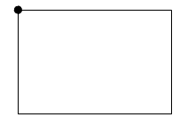
To calculate the perimeter of a rectangle, square, parallelogram:
P = 2 lengths + 2 breadths and the answer is in mm, cm, m or km
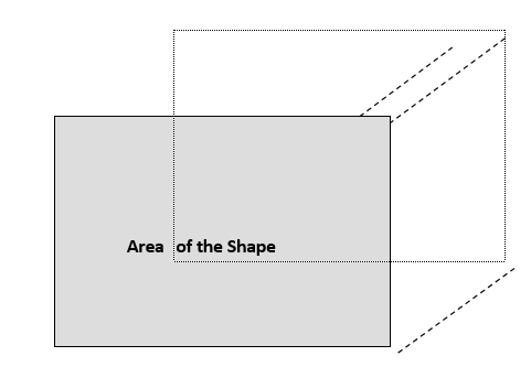
Area
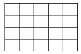
The area is the amount of space a shape takes up in two dimensions i.e. length and breadth. The example below shows how a shape with a length of 5cm and a breath of 4cm, takes up a 20cm space. The area is measured in square meters.
5 cm
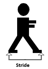
If you measure space such as a room, then you will estimate the length and breadth by using a stride. A stride is a very large step and is the distance between the heel of the back foot and the toe of the front foot.
Volume
Volume is the space that a container can take on the inside. In order to determine the volume of a container, we need to add another dimension to the shape i.e. the height or depth.
Up to now, we have calculated the area of a shape, working with the length and the breadth. The length is one dimension; the breadth is the second dimension. If we now add height or depth to a shape, we add a third dimension and we can see how much go into it. The dotted lines in the figure below show how we have added the third dimension i.e. depth.
Length x breadth x height
To calculate the volume, we multiply the length by the breadth by the height. The unit of measurement is also multiplied and we end up with cubic metres i.e. m³.
Volume = length x breadth x height.
The box below is 3cm x 3cm x 3cm. We fill the box with 1cm x 1cm x 1cm cubes. This illustrates the volume of a 1cm³ cube that can fit into the box i.e. 27 square boxes or 27 cm³.
Drawing Scales
Drawing scales are used to reduce the size of a large article so that it can be represented on a piece of paper. Maps normally use a scale to indicate to which extent a piece of land has been reduced.
The same principle is used in engineering drawings to illustrate the size of a component or engineering object.
A scale is a ratio of:
- the distance between two points on a map vs.
- the actual distance between two points on a surface
Scales can be represented in one of three ways:
as a ratio of 1:1 500 000
as a fraction 1/1 500 000
as a graphic scale
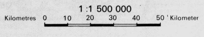
This means that for each 1 unit of measurement on the map, the distance is 1 500 000 of the same units of measurement on the real surface.
Example: A scale drawing is a drawing where the accurate dimensions of an object or figure or area are reduced or enlarged. The scale drawing is the exact duplication of the original figure, shape or object, but it is smaller.
An area is shown on a map as in the drawing below. The scale on the map is:
1:1 500 000.
We measure the length and breadth of this drawing, which is 10cm x 5cm. We can then calculate the actual size of the area land, represented on the map.
1: 1 500 000
1 x 5 : 1 500 000 x 5
5: 7 500 000
So for every 5cm, we measure on the drawing, the real measurement on land is:
7 500 000cm (or 7,5 km).
1: 1 500 000
1x 10 : 1 500 000 x 10
10: 15 000 000
The length in this case will be 15km on land.