Completion requirements
View
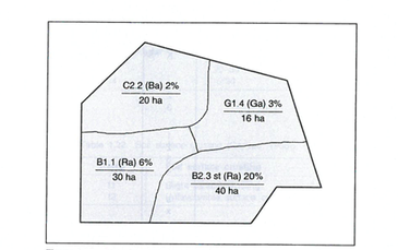
Once the ecotopes have been identified and mapped, the ecotope codes should be presented on an ecotope map.

Ecotope codes (adapted from Gerard, 1998)

An example of the separation of an area into crop ecotopes, with land use planning, is based on these units (adapted from Gerard, 1998).
Click here to view a video that explained soil and soil dynamics.