Completion requirements
View
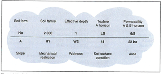
Identifying soil forms and families requires considerable knowledge of the soil classification system. On the base map, the soil characteristics are described in the form of a soil code.
Soil Codes

Soil code depicted on a base map (Gerard, 1998)
Soil Symbols
|
Soil form |
Hu |
Hutton |
|
Soil family |
2 000 |
Mesotrophic |
|
Effective depth |
1m |
|
|
Texture A horizon |
LS |
Loamy sand |
|
Permeability |
6/5 |
Rapid/good |
|
Slope |
A |
0-3% |
|
Mechanical restriction |
R1 |
2-10% |
|
Wetness |
W2 |
Temporarily wet |
|
Soil surface condition |
t1 |
Slight surface crusting |
|
Area |
22 ha |
Hectare |
Soil Slope
Soil slope class dependent on mean annual rainfall (Gerard, 1998)
Soil Texture
Effective Depth
The effective depth of soil depends on mean annual rainfall.